Hiking trough history - Le Vanel
11.07.2022 Arts & Culture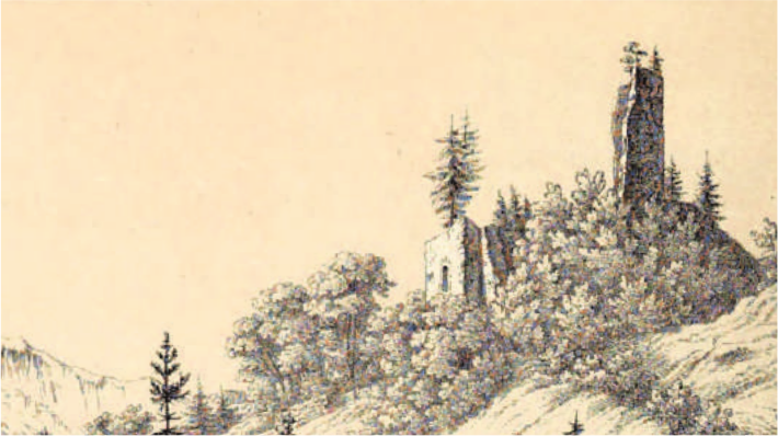
One of the most iconic 19th-century images of the Saanenland must be the rustic and picturesque lithograph of the ruinous château du Vanel drawn by Johann Friedrich Wagner (1801-aft. 1850) in the early 1840s at the very height of the Romantic Era. Conifers growing from the tops of the donjon and outbuildings, leafy groves storming the remains of the curtain, it resembled nothing so much as the ossified carcass of a colossus embracing his final rest. Lord Byron’s companion John Hobhouse noted it only in passing as he fished the Saane from Rougemont to Saanen in September 1816 – one can only suppose that the poet would have made a bit more of its brooding grandeur, had he bothered to put it in his journal.
Though there’s not much to see today beyond scaffolding as the municipality of Rougemont attempts to buttress the remaining dry stonework on the hillside, the crumbling edifice has captured the imaginations of travelers throughout the modern era. Built in the 11th century by the counts of Gruyère, the fortification controlled the narrow passage of the Vanel gorge to both consolidate and protect the eastern border of the county of Gruyère, and the priory of Rougemont, from encroachment by the Alemannic peoples of Saanen and allow for future expansion into the Saanenland.
Hisely, in his Histoire du comté de Gruyère (1851), explores the origin of the name Vanel in exhaustive detail. Citing the Ducange Glossary, he derives it from Latin vena (vein), meaning a tight, arduous path, which in those pre-roadway days it certainly was. The only practicable path through this traffic chokepoint passed through the enclosure of the fortress, which guarded the mule paths to the passes of Saanenmöser, the Sanetsch, and the Col du Pillon.
The Vanel castle was the administrative center of the castellanies of Rougemont and Gessinay (Saanen), dispensing high and low justice, housing the tax rolls (Zinsrodel) and medieval land registers (Urbar), and enforcing the count of Gruyère’s manifold rights in the Saanenland. For capital crimes, a Galgenmättli, or ‘gallows meadow’ (today Galgeli), rested just to the east.
It was the focus of disputes, as all such liminal areas are – if in doubt, see the rock at the nearby road pullout that celebrates the demise of the so-called Röstigraben. The lords of Raron in the Valais shared tax rights with Gruyère over farmsteads west of the Vanel, which inevitably led to disagreements. In 1331, Johann von Kramburg, who had a fortified tower above today’s Krambrücke (at Chalet Flora), claimed ownership of the Vanel castle and attacked it, after demanding 1000 pounds (of Berner écus blancs) from Gruyère for cattle raids.
Finally, in 1407, the combined forces of Berne, Thun, Frutigen, and the Simmental overcame the garrison at the Vanel and destroyed the castle. For the next 500 years, the keep’s skeletal remains lingered, occasionally dropping rocks on the road below, until 1907, when a bolt of lightning knocked it down for good.
ALEX BERTEA
THE HIKE
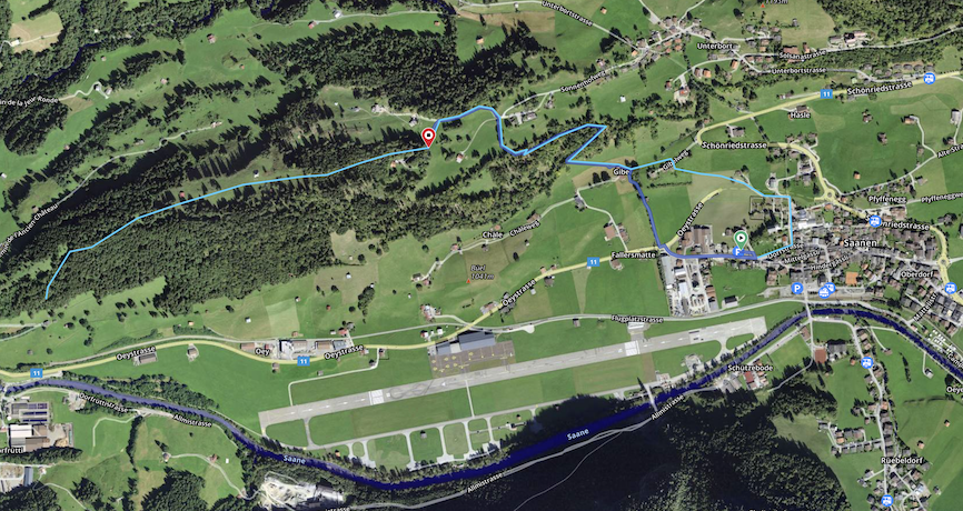
Start in Saanen and hike up to the Restaurant Sonnenhof on the Unterbort (about 1.5km). Proceed up the Sonnenhofweg a few hundred meters and turn left at the Mangelsguetweg. Follow that to the hiking path. The entire hike is approximately 4km to the Vanel ruins, with a total ascent of approximately 218m and descent of 214m. Le Marengo is the highest point, at 1230m. The route is mostly forested with lush glades and meadows filled with stunning wildflowers. With a 5-yearold in tow, a leisurely pace, and plenty of pauses for distractions, it took our family about an hour and 45 minutes. Enjoy!